
Coast Part 2b
The second half of this trip finds us with more miles to do, as the crow flies, than we have done already but with the prospect of better roads and less out and back bits involved.
Day 5 The Eden Project
We spent all day at the Eden project, this was fantastic. Plenty to see even in this season and of course in the domes, or biomes as they refer to them, the seasons are what they make them. The plant in the picture is Amorphophallus titanum which is supposed to be the largest flower in the world, this specimen was a little on the short side the bud being only about 1.2m high when we saw it but it is still growing.


Eden Project
Day 6 St Blazey Gate to Helston
A couple of miles from our camp site we found Charlestown with two square riggers in the harbour. I have been through St Austell many times and never realised this was here, we would have missed it but for wanting to miss the early morning queues into St Austell and of course wanting to stick closer to the coast on our way to Mevagissy.

Charlestown Harbour
Having taken a few photographs we then went on to Mevagissy, which we passed through before 9am! All the time we were listening to Wogan's auction on Radio 2 in aid of Children in Need with the bidding to have Aled Jones and Katy Melua sing getting towards a quarter of a million pounds! Unbelievable.

Mevagissey
We stuck closely to the coast all around to the lighthouse at St Anthony Head (Zone Point). This included a stretch of road down to Hemmick beach that was far too narrow for comfort. All the little coves and harbours seem to merge into one in my mind. Certainly as I look at the photos I can't easily remember which is which, perhaps I should start a competition 'Spot that Cove'. We stretched our legs at St Anthony Head (note no 's). We spent Christmas at the lighthouse cottage in 2002, just after the water main was repaired and all the water was brown. Buying all our water at St Austell and carrying it down to the lighthouse along with all our our Christmas goodies was some chore. By the way did you know that St Anthony lighthouse was 'Fraggle Rock'? Fulton Mackay played the lighthouse keeper in the UK version with the muppet like characters also devised by Jim Henson.


Pendennis Head, Falmouth from St Anthony and vice versa
Lunchtime saw us at Pendennis head eating pasties, looking across to St Anthony, having gone around the Carrick Roads via the King Harry chain ferry. That was a big detour but more was to come as we went around the Helford River via Gweek to another St Anthony. When we arrived we could still easily see the first one that we had left over three hours earlier! Again the lanes were narrow in places, both coming and going from St Anthony in Meneage and so we gave Porthoustock a miss. At Dolor point, Coverack we also chickened out of the route up school hill, although it doesn't look too bad on the map.

Coverack
We were now on the Lizard penninsula heading for the most southerly spot on mainland Britain. They were doing road works at Cadgewith, we had two goes at getting down to the harbour but were forced back by diversions, still we did get close enough to see the sea there. The weather had been slowly getting more overcast and shortly after we arrived at the Lizard the first spots of rain started. Still we had arrived and one of the first big tick boxes: the most Southerly point of Mainland Britain was duly ticked. Of course there were plenty of the "most southerly xxxxx " including pubs, cafes, souvenir shops etc but here is our selection:


Most southerly cafe, lighthouse and perched seagulls on mainland Britain.
As we left Lizard rain started falling heavily and by the time we were at Mullion Cove very little of the sea could be seen. The next photo could either be Mullion Cove, Poldu Cove or Gunwalloe Fishing Cove, we can't remember. It was taken 21 minutes after Doreen took our last Lizard photo, so she had to climb back to the van, dry off etc and according to google maps its then 14 minutes to Mullion Cove so that looks most likely.

21 minutes after Lizard
We thought about a wild camp and looked at some likely spots around Gunwalloe and Porthleven but the thought of a nice long warm shower made us search for a campsite instead and we are so glad we did as we found a Camping and Caravan Club CS that we've awarded 10 out of 10 to.

6th day - 126 coast miles
Day 7 Helston to Camelford
The next day the weather was much brighter and after giving the dogs a good walk we set off again. Its very good light in the November early morning and after going through Praa Sands we stopped by the roadside to take several photos of St Michael's Mount

St Michael's Mount

Newlyn Harbour
Penzance, Newlyn, Mousehole and Porthcurno are well frequented spots of ours so we just drove on through but Doreen managed to squeeze off the above shot at Newlyn as we passed looking back towards Penzance. If you haven't visited the area the telegraph museum at Porthcurno and the nearby Minack open air theatre are well worth visiting.
We don't like what has happened at Lands End. Some years ago it was turned into a sort of theme park and frankly I won't even pay to park there. I've flown over it, low level, many times and its just crass. So when in the area I try and avoid it, and this time after using their car park to turn around went on to Sennen Cove then the totally unspoilt Cape Cornwall for breakfast. Later we drove along the twisty north coast road to St Ives. After parking up there we witnessed a massive gridlock in town. At the head of the queue which included buses pointing in different directions a police car and forty or fifty vehicles that we walked by was a hired Luton lorry blocking the road delivering a large oven to a pasty shop. We both stopped at a nearby cashpoints and after getting our money noticed the lorry was still there .... the driver and his mate were waiting for their pasties! We walked around the harbour and when we returned they had moved on, chaos still reigned, but as my Cornish mate would have said "madder do ee?" (does it matter?)


Cape Cornwall and St Ives harbour
The late morning and early afternoon were spent going into and out of all the little coves on the coast. At one stage we were forced inland a bit whilst making for West Pentire to eat our rapidly cooling pasties. Suddenly we caught up a double decker bus going down quite a narrow road. Well if he can get through we can relax we thought .... well that was ok until it met another double decker from the same company coming the other way. With some reversing and flattening of the hedgerow they passed each other. Only a few hundred yards further on it met another bus on an even worse bend! They spent five minutes this time, extracting themselves and I have to say the driver of the bus we were following didn't seem too good at it. I wonder if it happens every day? Still, madder do ee? Well yes it did our pasties were only lukewarm by the time we got to our viewpoint. Still we were still making good time and we passed our original planned stop at Padstow by three. Now the dogs were demanding a run on a beach so we stopped at Polzeath.


West Pentire and Polzeath
It went a bit pear shaped after that, there was an open camp site at Polzeath, but we went on further and as dusk was falling turned up at an 'open all year round' CS to find it closed. Phoning around and some cross country navigation later took us to a campsite some way off our intended path, which was less than ideal, as although they said they were open they were clearly not expecting further visitors this year. Water turned off (we had an empty tank) field unmown etc etc, still we got a good nights sleep and we had just had a glorious sunny day and had gone much further than expected.
Ten Years Later we found ourselves staying in a holiday cottage at Port Isaac. Whatever it shows on the map below we realise now that we 'jumped' from Polzeath to Trebarwith strand and this is confirmed by the list of places. This means we missed out on Port Quin, Port Isaac amd Port Gaverne. So we remedied that in our Fiat Panda. Now I have to say we might have got down to Port Quin in our Renault but we certainly wouldn't have been able to go down through Port Isaac in it we barely managed it in the Panda. In the campervan we would have had to go into Port Isaac on the main road and down to Port Gaverne. Now ten years aowe took our eye off the ball due to the lack of open campsites but after all we are only human. Now read on to Boscastle below.

7th day - 145 coast miles
Day 8 Camelford to Ilfracombe
I had studied this next bit of the route on the OS maps in some detail. The road to Bude looked straight forward but as we got into Devon we were going to have to do some retracing of our route as suitable coast roads just didn't exist. Still best to travel hopefully....
The day started inauspiciously, I had to buy some diesel at £1.09 a litre. Then we went to a beach for a dog walk, Trebarwith Strand, to find the tide in and no beach, then Tintagel was its usual disappointing self. By the time we got to Boscastle and found the road closed we sort of knew that the fates were against us. We went down as far as we could in Boscastle and saw them mending the bridge originally damaged in the June 2004 floods but apparently damaged again in floods in June of this year. We then went on a roundabout diversion until we got back to the coast at Crackington Haven for breakfast. The bridge there was washed away in June 2004 on the same day as Boscastle's floods. The road in and out of Crackington Haven wasn't as bad as the map suggested so suitably reassured we went on to Millook Haven. Going in was ok albeit narrow but coming out we were faced with a 1 in 3 with a 90 degree hairpin in the steepest and narrowest bit it took two goes and quite a bit of burnt rubber. The rest of the trip into Bude was a welcome anticlimax.
In 2017 we were able to drive into Boscastle and see, hear and read about the 2004 and 2007 floods. So along with our visit to Port Isaac et al now feel we have done a 'proper job' on this bit of coast.


Trebarwith Strand and down to Millook Haven
We were able to get to Coombe and Mortenstow, but the lanes were becoming narrower again the closer we got to Devon, and were getting further away from the sea. At Gooseham we were stopped from crossing into Devon by a 'Road unfit for motors' sign. This necessitated a diversion to the A39 but having got into Devon we then tried to get to the beach at Welcombe. We turned back, or rather reversed our way out, once the blackthorn bushes were touching both sides of the van. So back to the A39 and staying on, for us, fairly major roads, went to Hartland and on to Hartland Quay. Hartland lighthouse may only be approached on foot and then by people who are willing to pass lots of warning notices. Falling rocks from above and subsiding road below are just two of the hazards. The last time I went to Hartland on Trinity House work I had to fly down from the car park. So as I have been to the lighthouse many times before we purposely gave it a miss. Hartland Quay was a different matter, although I have stayed at Stoke which is less than a mile away I never managed to find the time to get to the Quay before. We got there just before the promised rain arrived just in time to get a rather good look at Lundy Island before the weather closed in.
There was no point in getting out of the van at Clovelly although we drove as far as the carpark to 'connect' again with the coast. Then it was on to Westward Ho!, Appledore and through Barnstable and back to the sea at Croyde. The last time I was here it was in full sunshine but even on a dull day Saunton Sands is impressive

Saunton Sands
Woolcoombe was closed and damp but we got some red sky as the sun started to go down. We arranged our campsite more carefully this time and had time to do a circuit of the cliff roads at Morte and Bull points as well as getting our confidence back with some narrow 1 in 4 work in and out of Lee bay before getting to the campsite for a well deserved shower and a wee dram or two.

8th day - 129 coast miles
Day 9 Ilfracombe to Avonmouth
Another sunny day dawns, the forecast though is for very bad weather so we have decided that whenever the weather breaks we will just head for Salisbury and in any case will go home tonight. (Saturday). We start off by going into the harbour at Ilfracome and get some groceries needed at home. Then off through Combe Martin to Stony cross and on to the coast road to Porlock taking every minor road that presented itself. I think I will let the pictures speak for themselves.


Ilfracombe Harbour and above Elwill Bay


Woody Bay Toll road and Valley of the Rocks


Foreland Point from Countisbury Hill and Porlock Toll road
It was then on towards Minehead, we were so far ahead of our plan that we could afford to go for a walk on Selworthy Beacon, so we did. Then back down to Minehead, it seemed a long time ago that we were at an MHF rally in the Butlins here, but it was only June this year. Minehead was overflowing with people again, so I guess there is some sort of off-peak deal for the masses at Butlins.
The weather was still holding so off we went along the Somerset coast and getting to a part of the coast that few other than bird watchers and locals bother to see, the outflow of the river Parrett over the mud flats at Steart point. Typing this I have realised another first. This is the first nuclear power station we have been near so far (Hinkley Point). Dungeness, which will be the last one, seems an awfully long way away. From here we could also see across to the next high ground Brean Down. These pictures remind us that we haven't been anywhere remotely flat recently.
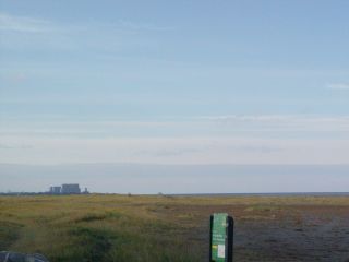
Hinkley point

Brean Down (with Steep Holm to the right)
It was in 2006 that we attended our first MHF rally at Brean and today we bought a late lunch of fish and chips and sat in the car park opposite Warren farm and ate them. The weather still didn't turn so we were able to get to our desired end point the river Avon near Bristol, from which we will pick up the challenge to complete our journey all around the coast of mainland Britain sometime in 2008. We will just leave you with a picture of the second severn crossing which as well as being the end of this part will be the start of the next.

SSC and Battery Point, Portishead


9th day - 136 coast miles