
Picos de Europa
The Picos De Europa is a more or less triangular shaped mountainous region bounded by the three roads N625 from Cangas running down the west side to Riaño, the N621 running up the east side from Riaño until it meets the AS114 which crosses back across the top to Cangas.

KEY Blue Arrows our route, Red Arrows: 1 Posada, 2 Fuente De, 3 Campsites at Potes
This map represents 60x55km
The name is interesting, apparently they were the first thing a sailor returning from the new world would see as he approached home. It was the place we wanted to see and juggling with our itinary and the weather forcast kept us busy for a couple of weeks. We did get it right finding a window of good weather and it became our highlight.
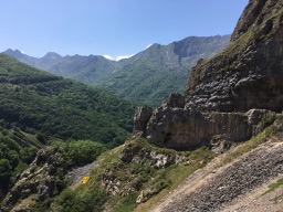
Covadonga is just inside the Parque National de los Picos de Europa (a mouthful I won't be repeating) just 11km from Cangas. You will have read that we didn't get to the lakes of Enol and Ercina a further 12km in. So when we returned to Cangas we decided to follow the blue arrow south towards Riaño through the gorge Desfiladaro de la Beyos which becomes more and more exciting as you go south. We were able to stop once or twice to take in the view and marvel at the limestone cliffs which in some places seemed to meet overhead. some of these photos were taken quickly through the windscreen with the inevitable reflections.
.jpg)
.jpg)
.jpg)
.jpg)
.jpg)
.jpg)
.jpg)

From here the road climbed out of the gorge on a road that twisted and turned, climbing all the time, until we went through a small village hanging on the hillside and through a tunnel and then were able to stop at a viewpoint where we were viewing everything around and a lone goat was clinging on to the rocks above observing us.


After passing 1200m we started to descend a little. Then we then took the minor road LE244 to Posada de Valdeon. This road was probably one of the easier ones we travelled on in the mountains and went over two mountain colls at around 1300m and 1500m. Note that road signs indicated the road had a different number and our detailed tourist map of the Picos said one of the colls was at 1806m but we were sure that was a misprint. When we were at Posada we were surrounded by mountains rising above 2600m Posada itself was at 900m The aire might as well be considered a campsite that only charged €10 rather than an expensive aire. All the facilities were there including free showers in the adjacent sports hall. One Dutch woman was complaining about the price expecting a discount for not being on electrical hookup which was included in the €10 but for which you needed a long lead. We thought it was good value just for the view,
.jpg)
.jpg)
.jpg)
.jpg)
.jpg)
.jpg)
.jpg)


On day 2 of our time at Posada we went for a walk in the morning ending back at the village for a beer, the village photo shows the pub next door to the restuarant which we used that night.


Ok Confession time, that isn't my photograph of a griffon vulture but it roughly corresponds to the image through my binos of the one that came closest.
Funny story
So at Posada we stayed up late and went for dinner at 9pm! The owner acted as our waiter and delivered the menu orally in his own brand of english "for first plate it is possible to have ..." etc. On offer for second plate one of the dishes was "Chickpea stew' which Doreen ordered . When it arrived she was astonished to find it looked like meat parcels. No we were informed it was definitely correct: Chickpea Stew. By talking to the Spaniard at the next table we discovered that it was actually cheek of pig. What made it even more bizzare was that our guidebook mentioned that this restaurant's speciality was Chickpea stew. It was actually very nice.
The next day we climbed out of Posada heading south passing over the coll and viewpoint at 1562m then carried on down to the N621 at about 1230m.


Again the road steadily climbed but there were fewer hairpins and near Mirador d Lleshaba we came to a summit at 1675m. We then decended by one of the steepest and prolonged series of hairpins back down towards Potes all the time we encountered cyclists toiling up the hill towards us, by La Vega de Liebana we were at 469m and the road straightened out. At Potes (291m) we needed fuel but the one pump fuel station in Potes did not have diesel. So we had to go a little further on to the eastern edge of the town. Now we retraced our path headed back through the town on the CA185 we passed our intended campsite and headed back into the mountains steadily climbing to Fuenta De where there is a large carpark and the cable car.
.jpg)


.jpg)


Once we had some lunch it was into the cable car for the 4minute climb to the top at 1905m thats a rise of about 900m There is a cafe and a shop at the cable car terminus and paths leading on to the mountain where some intrepid walkers follow trails back down to Fuenta De. Looking over the near vertical drop to the valley floor we were glad we had bought return tickets. We then drove back to Potes and our terraced campsite. Potentially there was bad weather coming and we resolved to stay for a few days do laundry and have a rest, That afternoon chatting casually to Dave and Mary from Weston Super Mare we found out we were on the same ferry back and that they were moving on the next morning they bequeathed us their pitch facing the mountains.


Each day we were there an eagle circled in the late afternoon the closest it got to us was about 100m away when it was only 10m above a house adjacent to the campsite. It had been already identified to us as a short toed eagle. Close it might have been but how anyone could see its toes beats me. The threatened rain came to us as we were doing a BBQ one evening but our trusty Cadac coped with the downpour. We spent the three days at rest for the most part feeding sparrows etc and looking at them and the mountains.
When we left we rejoined the N621 and passing through a gorge left the Picos, thats not to say we stayed out of the hills, far from it but they were no longer the magnificent limestone mountains of the Picos de Europa.
Back To Blog: franksblog.webnode.com/blog/spain-2017/