
Coast Part 3
The next stage of our trip around the UK coastline was to be Wales and a little bit of Cheshire and Lancashire. My work (Trinity House Lighthouse Service) had taken me to many parts of the Welsh coastline and in the early 70s whilst in the army I lived on Anglesey, so there were stretches of the coast that I was reasonably familiar with. We decided however that we wouldn't attempt the daily mileage that we had achieved around the Cornish peninsula (See Part 2). There we averaged well over a hundred miles a day, and although we already knew much of the coasts of Dorset, Devon Cornwall and Somerset with hindsight we decided that it had been too rushed. One other change from Part 2 is that we had two new reference sources. For Christmas I was given the complete DVD set of the BBC programme 'Coast' and we found a freebie Guardian guide to the Seaside. We sarted out on the 26th April 2008. Doreen's back had been hurting her so we set out a few days later than originally planned to let the chiropractor do his work.
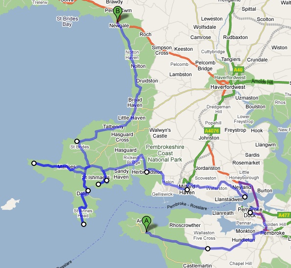
Because the blog is so long I have broken it into two parts which are basically:
3a West to Pembroke
3b North and East to Preston
I shall repeat the warning of earlier parts, we have a reasonably slim panel van conversion and its only a little over five metres long. Many of the lanes we travelled down would be unsuitable in anything much larger.
Day 1 Across a Bridge to Cardiff

Second Severn Crossing (SSC)
This day could be subtitled a tale of four bridges, the one shown above being number three. We finished Part 2 by crossing over the River Avon on the M5 so set out to start it by going under the same bridge. That wasn't as easy as expected and we had to backtrack to Shirehampton from the M5 to pass under it. Still just a five minute detour, one bridge done and on to Avonmouth, I used to work in Avonmouth, so we soon got lost in the back streets!
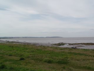
Low water at Severn Beach
I am almost sure that Severn Beach was once described as a 'Riviera' seaside resort on a railway poster, just a touch of exaggeration perhaps, still it was an important day trip destination for Bristolians when I were a nipper. A brief walk with the dogs and then on up to the original Severn Bridge at Aust. It was closed! Ok lets see how to get to the SSC from here ... hmmm.... after looking at OS maps we realised that wasn't going to be easy, the Almonsbury interchange where the M4 and M5 cross doesn't seem to allow for a 'U' turn, so we either had to retrace our steps to Avonmouth and come back on the M49 or get on to the M5 at J17 or J18 or .... and this was only an hour in to our coastal odyssey. Still, half an hour or so later we were paying our £5.60 having arrived in Wales. Lunch was at Redwick and a little later we dallied in full sunshine at Gold Cliff looking over the mouth of the Severn Estuary/Bristol Channel to Portishead and Clevedon with the SSC just discernible upstream. The Bristol Channel is famous for its tidal range and as can be seen when the tide's out it's really out.


The Severn at Low Water
Our 4th Bridge of the day was also closed, but this was expected, as we knew its last passengers crossed at Christmas. I refer to the Newport Transporter Bridge. It is said to be reopening soon when some new parts are ready, I do hope so, as it's a magnificent engineering monument. How does it work? Well most of the structure is static, apart from a runner at the top level which has a piece of road suspended beneath it. This piece of road with a few vehicles on it is sent back and forth like a sort of chain ferry. Hopelessly inadequate for today's loads and traffic flows but an important contributor in its time to Newport's infrastructure.
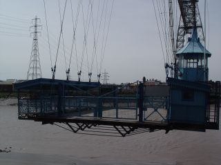
The Road
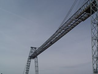

The Newport Transporter Bridge
We then went off to Cardiff where we stayed in the excellent municipal site near the city centre. Note all campsites are in the MHF campsite database and as mentioned earlier a different blog has a list of them all.
1st day - 71 coast miles
Day 2 Cardiff to Porthcawl
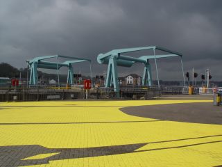
We drove down through the 'Tiger Bay' area of Cardiff, now known as Bute Town to the docks, where the Welsh assembly building looks out over the water. There are many new buildings, structures and works of art on display, so it was well worth walking around even though rain threatened. One slight oddity: a wooden Norwegian church. The story of this church which is very old can be found in the links at the end of this blog. We then drove to Penarth to see the Cardiff bay Barrage and its locks. Wales is supposed to be the land of the speed camera but we can tell you it's the land of the sleeping policeman and most of these road humps are in Penarth!

Cardiff
After watching loads of small yachts lock in to the bay we carried on to Sully where we had an extensive lunch in the 'Captains Wife' Inn before arriving at Barry Island. I don't know if Barry Island ever had a glory to fade from, but if it did, then its definitely faded. (Afternote This was written before I was aware of 'Gavin and Stacey' who brought Barry to public attention - the show was originally on BBC 3) The promised rain started to fall which made it look, if possible, worse. So we pressed on and almost immediately after passing Cardiff airport the view and weather improved.
We went down the single track road to Col-huw Point. We had to keep stopping for oncoming vehicles which we then noticed were all VW vans (the Transporter I think though in different variants) when we got to the point there were still more of them setting off. I've googled but can't find out more, seems odd, rallies with VW campers I'm sure are commonplace but commercial van rallies?
We were now in full sunshine and a visit to Nash Point seemed a good idea but we turned around at the parking place, 4pm and they still wanted a full day's parking fee! A few miles further on we stopped for the view alongside the Ogmore river and arranged to visit a C&CC CS near Porthcawl for the night.
2nd day - 64 coast miles
Day 3 Porthcawl to the Gower
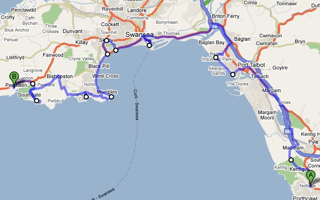
On these trips you tend to have preconceived ideas about places. I have often passed Port Talbot on the motorway and thought, what an awful place, but the reality couldn't have been more different. We started from our campsite near Porthcawl and straight away stopped at Kenfig. This extensive dune system and wildlife habitat gave the dogs some much needed exercise. Margam and Port Talbot seemed quiet tidy places and Aberavon sands has obviously had some money spent on it.
Aberavon
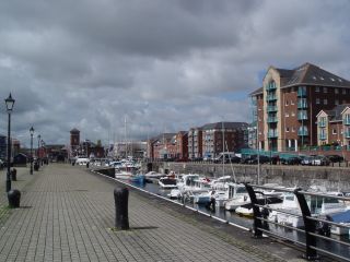
We had arranged to meet a former colleague at his house in Swansea in the afternoon. We killed time before our meeting in the refurbished Swansea docks. A very pleasant hour or so looking at boats enjoying one of the biggest bowls of soup I have ever encountered and generally chilling (us not the soup):
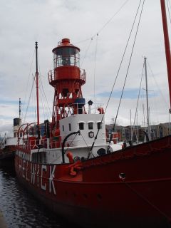
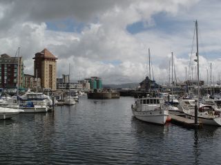

Swansea
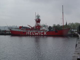
For the more observant amongst you the coin propped up against the soup bowl is a 50p, and yes the Light Vessel in Swansea has the same name as the one in Cardiff; Helwick. Lightvessels have a number and a station. They were painted with the name of the station each time they were sent out. So each one could have had many names over its life. The number always stayed the same though, the one at Cardiff is number 14 and the one at Swansea number 91. The Helwick bank, where they were stationed, is off the Gower and is an important source of dredged building sand.
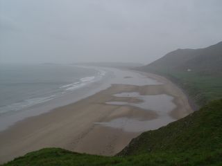
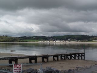
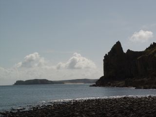
We have been to Mumbles and the Gower before, then staying at Gowerton CC site. This time we decided to stay in one place for two days whilst we explored all the coast, so after visting the Mumbles Casswell Bay and Southgate we arrived at our campsite near Penmaen. This turned out to be the most expensive site we used on this stage, at £17 per night with showers extra, but what a view. This tidy independent site looked out over Threecliff Bay and had a private, very steep, path to the foreshore.
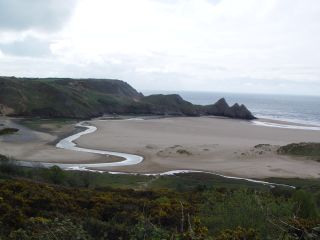
View from Three Cliff camp site
3rd day - 45 coast miles
Day 4 The Gower
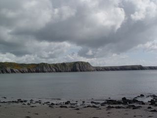
With heavy rain forecast we spent the morning walking in the bay, Pennard Burrows and down to Parkmill and back through a wood full of wild garlic and bluebells.


Walking round Threecliff Bay area
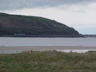
The forecast rain arrived, our last holiday in the Gower was rained off but we were on a mission so we soldiered on. We didn't get out of the van much. At Rossili I said that I wasn't coming all this way without seeing Worms Head, so off I went in the driving rain one quick snap and then into the NT shop for a browse. Doreen was very concerned that I must have drowned I was away so long. Had to confess where I had been as I was only soaked not drowned.

Worms Head and Rossili Beach in the Rain
We carried on round all the extensive out and backs necessary to reach all the beaches of the Gower, then damply drove back across the peninsula back to our campsite. I'm sure it must look brilliant when sunny but for today we just ticked the boxes. Typical exchange "Oh that's where the sheep live on the salt marsh and have to be rounded up if the tide is high", reply "Yep".
4th day - 52 coast miles
Day 5 Gowerton to Saundersfoot
Although a black cloud came over me as I walked the dogs this morning that was the end of the bad weather so by the time we left the Gower full sunshine was restored. I think its safe to say that we will be back to the Gower but next time when better weather is expected as that is the second time we have been there on rainy days. There was going to be plenty to see and do today and we didn't have any idea how many miles we would travel, this is part of the fun especially if you can have holidays with no fixed end date.
Just a few miles away we arrived at the seaside at Llanelli, literally, as there is a part of Llanelli called 'Seaside', in it we saw this very appropriate pub.
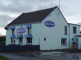
The Bucket and Spade
Nearby and partly facing each other there were two almost identical chapels. Each built and enlarged within a few years of each other. I wonder what schism separated their flocks? One was a Bethel the other a Shiloh. A bit of googling has revealed that there were very many 'brands' of chapels in Wales. Did they or didn't they all get on?
The pretty harbour of Burry Port was in the sun as we looked back over to The Gower. In the distance we could see waves breaking on an offshore bar. I took a bit of time over this next picture and although I haven't caught it exactly right I'll give it more space than the others.
Burry Port
With the estuaries of the Gwendarth, Towy and Taff to go round and Dylan Thomas's home to visit we didn't linger too long at Burry Port and soon we were going inland to skirt Pembrey Forest, heading for our next stop and a welcome cup of coffee at Ferryside. There we gave away about our 10th MHF welcome card so far this trip to a couple who seemed very interested in all things panel van. Across the R Towy lay Llansteffan, which is a picturesque spot reached after detouring around Carmarthen (and visiting the Morrisons there). Clearly the view from Ferryside is better than the view of Ferryside, so much so that when I took my photo from Llansteffan I pointed the lens at a train just leaving Ferryside rather than at the village
Llansteffen from Ferryside and almost vice versa
Dylan Thomas did much of his work at Laugharne writing in a shed near his home. It is believed that Llareggub in the famous 'Under Milk Wood' is modelled on Laugharne and its people . We have it on CD featuring Richard Burton so settled down later that day to listen to it. Even in those hallowed surroundings I still fell asleep before the end and so still don't know if Mr Pugh murders his wife, or if Myfanwy and Mog get it together. What I do know is Llareggub is 'buggerall' backwards and that got me checking all the Welsh place names in reverse to look for similar jokes.
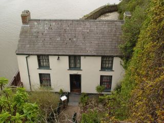
Dylan Thomas's House and writing studio/shed
It threatened rain at Pendine, I popped into the free museum expecting to see Parry's record breaking car, there was a gap where it should have been with no explanation, so we moved on. We had a number of camp sites earmarked in the area and on our route but with the heavy rain that had fallen earlier in the week found them either overgrown or waterlogged so the idea of it being fun not to know where you were going to end up began to fade along with the sunlight. Eventually we found a CS near Saundersfoot that had hard standing

5th day - 86 coast miles
Day 6 Saundersfoot to Pembroke
The day dawned bright as the red sky last night had presaged. They were digging up Tenby so after two attempts to get to the shore we gave up and put off breakfast in favour of brunch. The dog exercising area this morning was to be at the end of a narrow lane that led to Lydstep Haven, I would do my normal disclaimer about wide vehicles here except that at the bottom there are many mobile homes which must have been transported there somehow and presumably down the same lane. Looking left you see Giltar point and straight ahead is Caldy Island
Views from Lydstep Haven, Giltar left and Caldy straight on
We were heading towards St Gowan's head but one of the obvious stopping places was Freshwater East. There are five roads in and out of Freshwater; the first said 'no through access', the second 'unsuitable for motor vehicles', I forget what the third said. Personally from the map I wouldn't have gone down the second one but I think the signs were a local conspiracy to marshal visitors. Having gone the long way around to Freshwater via Lamphey we were disinclined to stay, so we exited on an even smaller road (according to the map) to Stackpole Quay which has an NT car park. We are not NT members, because they don't allow dogs on to many of their properties, but on this part of the trip alone we spent over £15 on NT car parks which are free to members, so perhaps its time to reconsider. Anyway the real reason for coming to Stackpole is the walk to the unspoilt Barafundle Bay. We could have spent all day wandering around the various paths inlets and headlands as it was we wore the dogs out.
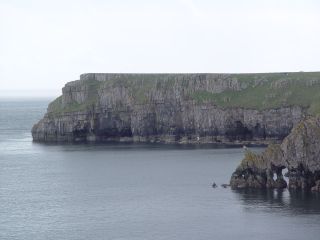

Stackpole Head and Barafundle Bay
St Govans head is featured in the BBC programme 'Coast' but somehow I got the impression that getting to the tiny chapel set in the cliff face was an arduous task. It wasn't, 70 something steps down (its a local legend that the steps are uncountable) and there we were.
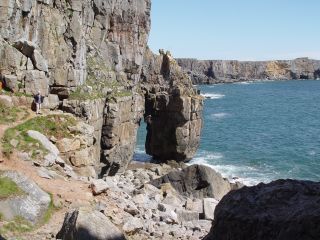
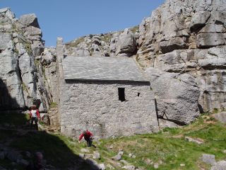
St Govan's Head
The army tank ranges of Castlemartin start alongside St Gowan's head and which roads are open depend on what is going on. One of my dogs had been flinching since arriving at Stackpole with the sound of the guns firing. So it wasn't any surprise that access in the area was limited, we didn't get to Elegug Stacks and had to make some detours. We actually stopped for a while at an official gunnery viewpoint to watch armoured vehicles rearranging some of the landscape with their heavy guns accompanied by the crackle of small arms fire. Later that night there was to be a real spectacle with helicopters firing tracer rounds into the target area. We carried on to the Southern tip of Pembrokeshire and enjoyed the views at Gupton and Bloomhill Burrows as well as West Angle Bay before retracing our steps slightly to our campsite. It was very near the Chevron oil refinery and it made an impressive backdrop. I did park the van so that we looked out to sea but later that evening, looking at the refinery with its thousands of lights, that was even more impressive (and annoyingly I can't trace that photo).

Gupton Chevron

6th day - 43 coast miles
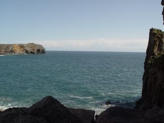
Day 7 St Ann's Head
I've probably spent around three months in all in the area of St Ann's Head. Various lighthouse projects on St Anns, South Bishop, Smalls and Skokholm meant I kept returning there, if not billeted offshore I would stay in Dale or Marloes. So the challenge would be to find new things in the area. First though we had to get round to the other side of Milford Haven, this we achieved by lunchtime and I was able to shoot this picture of Dale from an entirely new direction for me, a spot near Musselwick.

Dale
Nowadays you are not allowed to drive up to St Anns Lighthouse but seeing a MBB105 helicopter with an underslung load we drove there anyway confident that I would meet old colleagues. After a short conversation with some contractors we turned around and went off to Martin's Haven and Wooltack point. In about 1990, when mobile phones were the size of a house brick, we arrived there to catch a boat to Skokholm. Peter, a colleague, was there and wasn't in a good mood having just been made to pay at the NT car park and having found the boat had left already without us. A sweet old lady in tweeds who was waiting for the boat to Skomer saw his borrowed phone and marvelled at the technology, "Aye lass aye" Peter remarked, which immediately became "the !****** stupid !****** phone" etc when it became apparent that the battery was flat. Sweet old lady didn't turn a hair whilst the rest of us looked for stones to crawl under. The NT car park costs £3 nowadays but there is an interpretation centre that wasn't there before and a shop which has a high definition camera feed from Skomer so we were able to watch puffins without going to the bother of getting on a boat


Dale St Anns Head

Martin's Haven
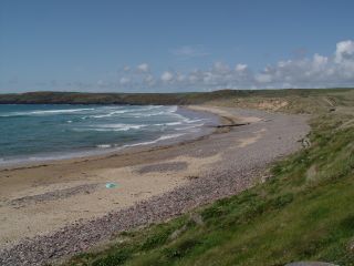
Having spent a few hours at Martin's Haven we then just drove to Newgale. To my great regret we didn't take any more photographs but the views were stunning, especially the road that clings to the coast from Broad Haven to Newgale.
7th day - 56 coast miles
Link to Norwegian Church www.norwegianchurchcardiff.co.uk/content.asp?nav=113&parent_directory_id=2
Link to Part 3b Coast Part 3b 2008