
Coast Part 4b 2008
Day 13 Milnthorpe to Haverigg
The day was lush and green and sunny as we continued around Morecambe Bay. At Kent bank we were able to see the first walkers getting ready to cross the bay to Morecambe Lodge, at least that was what we thought at the time, but by the time we had driven a few more miles we realised that the tide was flooding in not ebbing out. At Humphrey Head Point we saw what was either the worst case of fly-tipping ever, or a warning not to leave your caravan to the mercy of the seas.
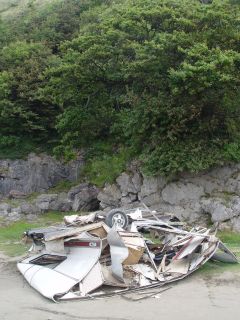
Bargain - Needs work
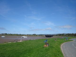
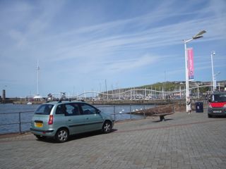
When we looked back across the bay to Morecambe it still looked as if it was raining there but the blot that is Heysham power station still stood out as the dominant feature. Near Ulverstone we filled up with fuel for the first time since leaving Salisbury (we had bought 30 litres on the Isle of Man but that was at £1.40 a litre). This was the first time I've put over £80 of fuel in a vehicle and I'm sure if you read this blog in the future £80 for 60 litres of fuel will seem a bargain. However our practice of generally driving more gently was paying off, because a rough calculation showed that our consumption had fallen to about 38 mpg from its more usual 34/36. We were to find out later that we got over 39 mpg for the whole trip. Anyway I digress, by now it was sunny and it was early afternoon when we arrived at Roa island near to Barrow in Furness, we were hemmed in by a motorcycle rally, which at least gave me the chance to see some rare machines - how about this one for starters?
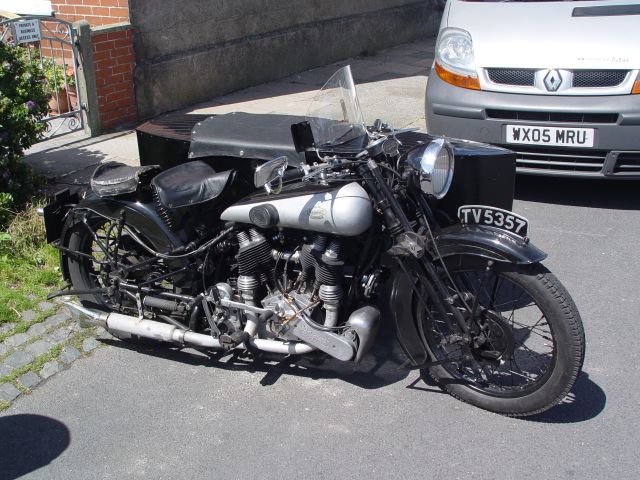
A Brough Superior
Our dogs scattering our laundry (see part 4a) reminded us we needed a mid-coast clothes washing session. One of the disadvantages of a small van and having to take so much dog stuff is there isn't room for a lot of clothes, so we do laundry every ten days or so. The one advantage of this arrangement is that the dirty washing doesn't get a chance to fester! Because of the uncertain weather we had left it to the last possible moment. Finding a launderette wasn't easy either, perhaps we need a POI for our GPS, and spending two very sunny hours on domestic chores was not best use of the weather.
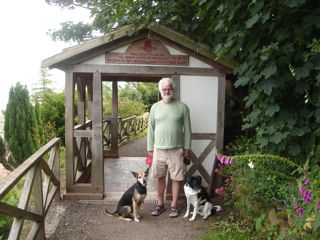
We thought about staying on Walney Island for the night but the site on the South end is a bit exposed and mainly statics, the tourers get pitched on the only sloping part of the whole area. So we phoned ahead for a site near Millom and continued on our way. By the time we got there all the laundry had been aired and could be put away. I do recommend a visit to this area though, most of us when that close to the lake district might opt for giving Walney Island a miss. The Lighthouse at Haws point used to be 'manned' by the only female Principle Lighthouse Keeper in the country, (perhaps in the world). The lighthouse was not a Trinity House one, but run by the Mersey Docks and Harbour Board. I visited once (we had a radio beacon there) and she addressed me from a bosun's chair, half way up the tower and told me in no uncertain terms that I wasn't to park next to 'her' lighthouse. After she came down and introductions had been made (she had thought that as I was driving my Romahome that I was after wild camping in her backyard) Peggy proved a gracious host and wouldn't let me on my way without giving me a tea of homemade cake and scones and cream etc etc. The MD&HB had employed some female keepers, but no others I'm sure got to be in charge. Since coming back I have done some research and she was 70 then, she died in 1996 aged 76, two years after retiring.
13th day - 95 coast miles
Day 14 Haverigg to Ravenglass
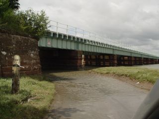
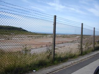
On this very sunny day we had a relaxed start giving the dogs a good run on the beach at Haverigg and made then made our way along the coast as usual. We came across the Eskmeals QinetiQ firing range and wondered how sensible it was having a firing range within sight of BNFL Sellafield. Lets hope they take all necessary precautions, especially as one notice indicated the experimental nature of the establishment. Shortly after we found that not all roads are passable; I especially rule out fording through salt water and having turned back, found our way around to the other side of the bridge at New Biggin to take the next photo.
We never intended just to stop at Ravenglass, but one of the beauties of not being over concerned with plans is that you can stop when you like, and so we did. We arrived there in the early afternoon and spent a few minutes looking at the Ravenglass to Eskdale railway operations. We decided to book into the C&CC site and spend the rest of the day going up and down the railway.
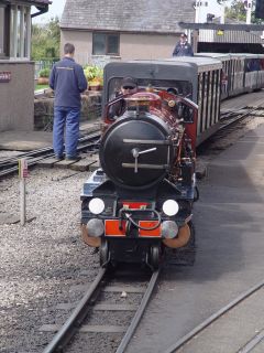
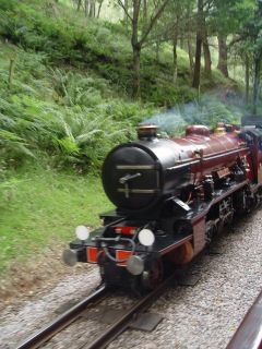
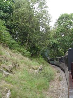
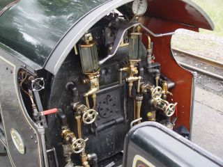
Ravenglass and Eskdale

14th day - 30 coast miles
Day 15 Ravenglass to Mawbray
The Cumbrian coast is full of contrast and this day showed some of its different faces. Ravenglass is peaceful with its silted up river (it was once Cumbria's most important port) then at Drigg the road to the shore curves around an elegantly landscaped, but seriously fenced, nuclear waste dump (BNFL probably have a euphemistic term for it, almost certainly with the words 'low level' in it) and then as you drive back from the shore the mountains form a backdrop to it. Then Sellafield itself, even in full sun it seems to possess a menacing aspect. Especially as you realise that when called Windscale, pile number number 1 caught fire and its core is still simmering away in a concrete jacket somewhere there. To the occupants of the police camera van that followed us to Sellafield station and back past BNFL, hello, no we weren't hoping to wild camp there.
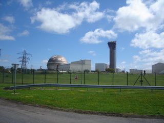
Ravenglass, Drigg and Sellafield
Then you get to St Bees, the shore car park was absolutely full, but a few miles away at North Head we were alone as we overlooked St Bees Lighthouse with the Isle of Man 40 miles away in the background, I had to go up a private road to get close to the lighthouse (don't tell anyone).

St Bees and IoM
As we approached Whitehaven there was this partly cleared industrial site overlooking the town and the sea which was, I think, a paint factory, and down at the harbour, instead of the dereliction that I remember, there were tidy flagstones and a marina. We should have looked for a memorial to John Paul Jones there but I thought it was at Workington, so not surprisingly when we got to Workington we didn't find it. More of him later. Then Maryport, the contrast here was again between the harbour area and the town, the harbour neat and manicured, the town in need of more than just a paint job.
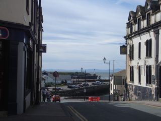
Whitehaven and Maryport
Then the scenery changed as Scotland suddenly seemed a lot closer, the Solway Firth narrowed and the towns gave way again to villages. We stayed at a small campsite by a pub that was recommended by Ian, another MHF member (Solwaybuggier) and had the excellent food and beer that he told us of.
15th day - 64 coast miles
Day 16 Mawbray to Powfoot
We have to say that Silloth was a great surprise to us, on the map not much more than a village with a campsite, then you go around a corner and there are very wide tree lined cobbled streets and impressive Victorian houses. Turn along the sea front, and there are large houses getting progressively smaller until you arrive at Skinburness, some three km away where a large hotel is being demolished.

The B road through Silloth
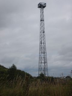
The next thing that we saw were huge aerial masts some distance off. I'm a retired radio engineer so I set to thinking what they might be and later we drove right by them. Now I've seen quite a few impressive aerial arrays in my time but nothing quite like these. From the size of the insulators they were clearly a transmitting rather than a receiving array and the whole thing was low frequency say in the region of 100kHz, so hazarded a guess that they might be to do with long distance navigation. I had half forgotten about them but waiting for me in Salisbury was the Trinity House magazine and inside a photograph of the self same aerial field, and I can tell you its eLORAN the latest ship and aircraft navigational system to go live, it gives accuracies similar to GPS but without relying on someone else's satellites, and the frequency - 100kHz, (I realise that only other radio people will be impressed by my powers of deduction).
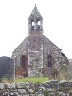
Just around from there is Bowness-on-Solway which is at the start of Hadrians Wall and a plaque wishes you well on the 84 mile walk to Wallsend in Newcastle. We probably have another couple of thousand miles to go before we get to the other end of that walk. The 13th century church has a set of bells stolen from two Scottish churches in retaliation against raiders who stole theirs in 1626, but dropped them in the Solway on their way back to Annan. There used to be a railway viaduct across the firth, allegedly it was finally demolished (in 1934) to stop Scots walking to England for a Sabbath drink. These stories remind you that the border area is different from both countries and it wasn't until the 18th century that the borders came under the respective laws of England and Scotland.

Bowness-on-Solway
We arrived at the outskirts of Carlisle in order to cross the river Eden and left on a minor road hugging its right bank. Almost straight away we spotted a lot of very tall steel towers much taller than the nearby electricity pylons. These were a mystery, the two rows of pylons are shown on my 2002 OS map but not these towers and there were a lot of them, perhaps 20. They all had a similar platform on the top and unlike the electricity pylons had a series of steps up through the middle. Our best guess was they are uncompleted giant electricity pylons. Unless they are a state secret can anyone shed any light on what they are for?
A Mystery Tower
And so on in to Scotland. Don't ask me why, but having got to Gretna we detoured to Gretna Green and the blacksmith's marriage cottage. We knew it would be a tourist trap and it was, for example the prices of some fairly standard malt whiskies were often 50% over what you would be charged in a supermarket*. Example I think the 12 y/o Highland Park was £43, a scandal. We did have a nice conversation, for an hour or so in the car park, with a couple from Wales about their home made panel van conversion. He said that he wasn't on the internet much (by now he might be an MHF subscriber!) but he listened to the problems other owners complained of and either did without or made sure his version didn't have the problem. So for example he had two leisure batteries, a compressor fridge, no roof vents, no shower room, no waste tanks but a lovely simple to erect bed, a large sink and a porta pottie under the large wardrobe, all the drawers used the 'glide close' system and stayed shut until you gave them a tug.
*Correction Tesco in Salisbury have today, 4/08/08, got an offer on the self-same bottle of Highland Park for £19.41 (a saving of well over £23)
Those of you who have read my blogs will know that we take a delight in visiting unusual museums (sardine canning museum Norway, ships in bottles museum Denmark) so how about a porridge museum? No ordinary porridge either - The Devils Porridge. In the first world war the British forces in France were running out of munitions and so they built a 9 mile long and 2 mile wide factory between EastRigg and Longtown and staffed it with 30,000 workers, mainly women. Devil's Porridge was the name that was given to the mixture of Nitro-glycerine and Nitro-cotton that was mixed by hand as part of the process to make cordite for shells and bullets. 3 years later it closed down, having made more cordite than all the rest of the factories added together. There is a link to the museum at the end of this blog - well worth a visit and very cheap by today's standards.
The second rip off of the day (although we didn't fall for either) was having paid a princely £16 for our campsite at Powfoot and £2 extra for our dogs they wanted £1 to operate the shower(6 mins). They also wanted enough information from us on booking in to open a bank account, have to confess, I lied a little.

16th day - 68 coast miles
Day 17 Powfoot to the Balacary road
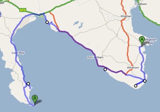
At this point we had to take stock, at the present rate of progress we would get to Troon during a big golf tournament, but if we didn't move on we would get caught up in the Wicker Man festival near Kirkcudbright. We had been based at Garlieston some years ago on holiday, so Wigtown, Whithorn and the Mull of Galloway were well travelled paths, we wanted to visit my relations in Prestwick, it was 'Glasgow Fairs fortnight' and we had an invitation to park up at an MHF members house at the end of our trip. The maps were consulted, all my planning skills were brought to the fore and so we decided to 'carry on and see how it goes'; you see all these years in project management have paid off.
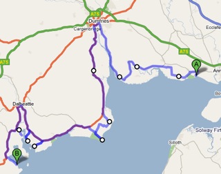
Caerlaverock castle is mentioned in an episode of the BBC Coast programme but on arrival found there was a charge for just looking at it from a distance, so we left after a free look and went into Dumfries, which is a lovely town, seeming crippled by bad traffic management. It had a helpful tourist information centre, free wifi in a pub, in a bookshop and in a library (guess where we chose?) and a well stocked whisky shop. As a rule I don't buy my whisky in Scotland its often too expensive I wait for the special offers in english supermarkets but the young lad in this shop knew his stuff - can you get a degree is whisky I wonder? I always have a soft spot (my wallet) for a good salesman and walked away with one of an independant bottling (Gordon and MacPhail) of a 17 year old single cask malt Ledaig (Tobermory). One to test the tasting experts with I fancy, oh and the price - £23, eat your heart out Gretna Green.
Right the promised mention of John Paul Jones, born in a cottage on the Arbigland estate some 12miles or so south of Dumfries. Famous as the father of the US Navy, but not adopted by them until 100 years after his death, having died a relatively poor man in Paris. In between he led a botched raid on Whitehaven, won an engagement with the British navy off Flamborough Head, both during the war of independence, and became a Russian Admiral. We went to his cottage (another little museum) where the curator gave us his undivided attention. I have added a link to his history below, but note that many 'facts' about his life are disputed, it depends where the historian is from.
We found Southerness a very unattractive place with its rash of seaside tat and couldn't understand the 'no overnight stay' notices in the carpark, I certainly wouldn't stay there, however it does have a nice lighthouse warranting a photo, sometimes it's open to the public when the curator can get away from the the JPJ museum
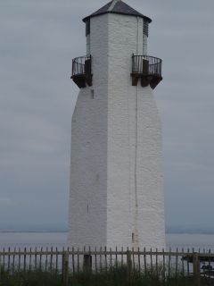
Southerness
We thought we might wild camp that night and although Rockcliffe and Kippford are very nice to visit we didn't linger at either place as they were obviously not candidates for a wild camp, being so busy. Wild camping is fine, but it does tend to make us a bit more focussed into looking at possibilities and hurrying on, especially as it was after five by then. We found a reasonable spot at Palnackie in its harbour, I think would have asked at the nearby pub if it was ok to stay there though. Palnackie people may be a bit odd, after all the local event is a 'flounder stomp' in the estuary - (you'll have to google for it but its cancelled this year). We found a spot between Auchencairn and Balcary Point. It wasn't ideal as it happened, there was quite a lot of late night and early morning traffic for a road that goes nowhere. We did find a better site but it was already occupied by someone who I guess was going on to the Wicker Man festival. Anyway first of all we went to the car park at Belcary point and walked around the headland. What a lovely walk, a bit frightening in places as the footpath goes along the cliff edge outside of the fence that protects the livestock, I don't mind heights but can't stand edges, an excellent walk none the less


Belcary Point
17th day - 78 coast miles
Day 18 Balacary to Garlieston
The Wicker Man is something of a cult movie starring Edward Woodward Christopher Lee and Britt Eckland it was set on an offshore Scottish island but filmed for cheapness near Kircudbright, a fact that the locals have been cashing in on ever since. (BTW Britt Eckland is not nude in the film, they used a body double). We drove past the site the day before the music festival, a layby nearby, was filled with what could be loosely described as motorhomes owned, apparently, by pagans. As we disappeared down the little roads in the area we noticed again that wherever there are army ranges you may not always get access but the roads around are well maintained. At one point we went to Abbey Burn Foot, this was down the narrowest road I've been on since getting stuck between two blackthorn bushes in Devon. The other side of Kirkcudbright we settled down for breakfast alongside Brighouse Bay, it was before 10 am, wild camping gets you up and about early sometimes.


8am, 9am and 10am
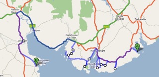
Too soon we hit the A75 and thus after visiting the Gemstone museum at Creetown quickly got to Newton Stewart, where we stocked up our larder in a supermarket. One troubling thing; just as we were leaving, I think a girl was taking photos of the van, and then she disappeared, could this be one of those insurance scams we hear about? Will have to wait and see if I am suddenly accused of damaging someone's car in a supermarket. As we arrived in Garlieston we noticed a new C&CC CS behind the CC site that we have been to before. It's not yet in the C&CC book but I'm giving it a '10/10' It was later voted CS of the year.
18th day - 78 coast miles
Day 19 Galieston to Mull of Galloway
Once you have passed the Isle of Whithorn in this part Galloway the 'coast road' is the 'main road' and so it stayed more or less all the way around to Drummore near the the Mull. So knowing that we needed to slow up a bit in order to miss the golf at Troon we had a lazy start leaving the campsite at noon and we stopped several times: At the Isle of Whithorn, to decide if the black blobs were seals or buoys, just when you had decided they were buoys they would yawn, near Port William, for lunch/afternoon tea and at Balgowan Point to let the dogs have a run and a splash.
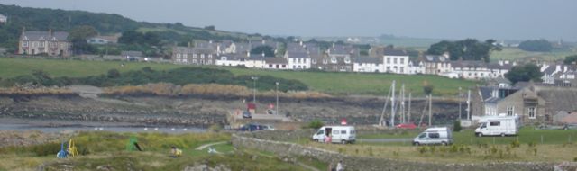
The car park at Isle of Whithorn
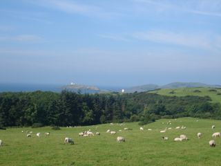
There had been a few stray wisps of mist during the day but by the time we drove up to the car park outside the Mull of Galloway lighthouse wall, just as the cafe was closing at around half past five, a haar (Scottish sea fog) was forming and worse there was the occasional drop of light rain. We stayed on the car park all night and we may, or may not, have been alone, certainly we didn't notice the car arrive that was there the next morning. It was sufficiently clear and dry by about eight pm to walk around and empty both dogs. We heard rain in the night though.
19th day - 65 coast miles
Day 20 Galloway to Cairnryan
It was still foggy at eight the next morning, one good thing, the Northern Lighthouse Board have discontinued the fog signal at the station, so we had a quiet night. The cafe opened at ten and we paid it a visit and bought coffees and cake. We generally had resisted holiday souvenir purchases thus far and there was no weakening of the resolve at the gift shop. The Mull was to cost us though. Almost suddenly the mist cleared and we we went to the RSPB centre near the light house. A warden carefully explained to us what birds were on the cliffs with the aid of a moveable CCTV system. He was such a nice man and so gentle with his answers to our simplistic questions that, half hour later, we were down at the fog signal viewpoint watching the birds in real life, fully signed up, as the newest RSPB members.
So after lunch we left the Mull in sunlight but a few miles down the road were struggling to see anything again. Here is the view at the allegedly pretty Port Logan


Port Logan early afternoon
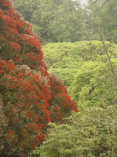
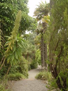
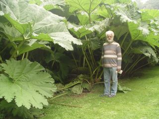
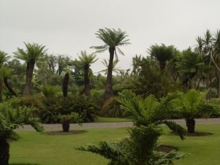
Just a few miles away are the Logan Botanic Gardens and well worth the visit that we paid it. My aunt was delighted with the shrub we bought her and I hope we will be pleased with the two small plants we bought. Also there was an outdoor exhibition of photographs 'Hard Rain' accompanying the words of Bob Dylan's song 'A Hard Rain's A-Gonna Fall', very disturbing images but why did the sight of a sea bird covered in oil strike home more than a young women dead for want of a few pence worth of tablets? See the exhibition if get gets near you. I'll give you some less challenging photos of the gardens.
We didn't take photographs for much of the rest of the day because of the haar. From time to time it would clear a little, only to return as we went on the many 'out and backs' along the west coast before turning south to Stranraer and on to Cairnryan. We had spotted several suitable wild camping spots but probably settled for the worse one. On a former industrial site I would imagine and in the company of travellers. Not that they were a problem for us but it meant that the landowner paid us a visit in the morning. As soon as he realised we weren't part of the group and were in the process of moving on he was positively friendly, you will be pleased to hear that I haven't added it to the campsite database. Also in the night there were passing ferries, or at least passing fog signals.

Corsewall Point LH now a 5 star hotel
20th day - 62 coast miles
Day 21 Cairn Ryan to Ayr
Its now Sunday, so the golf finishes today and we have invited ourselves to visit our relations this afternoon in Prestwick but we can't stay there and after two days of wild camping we need a campsite. Its also the middle weekend of Glasgow Fairs Fortnight, which is when traditionally, the working people of Glasgow took their holidays and, as old habits die hard, there might be a bit of a problem getting on a campsite. So we resolve to stop at the nearest C&CC site, at Culzean Castle, (pronounced cullaine) and if we can get a place, book in, and drive out and back to Prestwick, if not go across to Maybole and try there etc etc. We got to the site just after 12, to avoid the early arrival fee, and were able to get a pitch, nae bother. (Note, as I get closer to where I was Christened I start talking like a Scottish wurzle, a less than wholesome mix of Rabbie Burns and Adge Cutler). We then carried on as if nothing had happened along the coast to Prestwick.
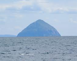
The grey haar had vanished only to be replaced with sun and sea mist. It meant that we didn't see Ailsa Craig properly, we either couldn't see it at all, or the summit was wreathed in mist or more bizarrely its base had vanished and you could see the pointy top. Even Arran was for many hours totally invisible, all the time though we were topping up our tans. One thing that intrigued us, what was the Electric Brae? Well its a piece of coastal road that looks like its going up when in fact its going down. It took us three passes to get the illusion and to make it complete you need to let your vehicle stop or freewheel and its better if you do that down the hill, which way is that? Well obviously when it looks as if you are going up!
(Google for a better explanation)
We spent all afternoon and evening in Prestwick then back to Culzean through the Electric Brae "Was that uphill?" ,"I'm not sure, I was looking for Ailsa Craig."
Just to be awkward I have counted the coastal miles for todays trip as ending at the bridge at Ayr not Culzean and tomorrows trip will officially start there and I've deleted the to and fro mileages from the coastal record, tomorrow gave us one more go at that damn Brae.

21st day - 52 coast miles
Day 22 Ayr to Glasgow
OK the last lap, but first why finish at J30 of the M8? Well I don't know yet how we will proceed next time. We could cross the Erskine bridge and stick religiously to the loch sides but is that really coast? Is Inveraray at the sea side? That way involves a lot of inland work and what about the Isle of Bute? Its hardly an island at all, shame to miss out Rothesay. The BBC jumped from Kintyre to Arran to Ardrossan on their trip. In short we are not decided yet but the furthest around we need to go whatever we decide is J30 M8. so thats how far we went this time.
All the little towns from Ayr onwards were packed, the beaches smothered and the smell of chips was extreme. Some of the nicest places had height barriers, shame on you Farland Head. There are a lot more marinas and the like, than there was when I was a lad up on holiday in the 50's. Cumbrae is a lot closer to Largs than I remember it too, perhaps the steamer went into Millport in those days. I'd like to think it was on a paddle steamer but I really can't remember. All I can remember is a rock painted to look like a dragon or sea serpent, and that a trip to Cumbrae was the highlight of a holiday.
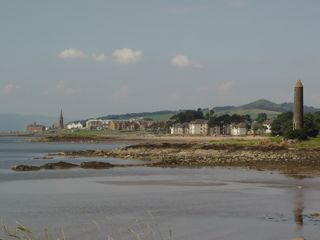
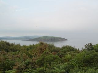
Largs from our lunch spot
The area was quite a surprise for Doreen, who had never been to this bit of Scotland before, who would have thought all those people would bathe in the sea this far North, and all that sunshine. We had the cab aircon on all day, just wait till I tell my cousin from Glasgow.
As we noted the mileage at junction 30 and made our way to meet Alan and Nancy (auldtymer) for the very convivial evening that followed, I thought, well we we wont be back to start here again until next spring. I have all the OS maps and a nice new planning map of Scotland however, so I can sort out the dilemma of how to do the next bit which will be from Glasgow to where? Inverness, Aberdeen, Edinburgh or even Newcastle? Yes, what about getting as far as Wallsend. Who knows all I know for certain is that we will be planning a week in the Orkneys.
22nd day - 77 coast miles
Link to a piece about Peggy Braithwaite MBE https://www.walney-island.com/walney_folk_01.htm
Link to the Devil's Porridge www.devilsporridge.co.uk
Link to John Paul Jones https://www.jpj.demon.co.uk/jpjlife.htm
At the end of Part 4 and our last in 2008 we had covered 2,685 miles of coast and our out and back journeys total 1,114 miles.
Link to Part 5 Coast Part 5a 2009